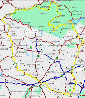
 Today I went on a crazy trip up to the Catskills. I'd already gone up to the general area around Catskill Park back about a month and a half ago, when it was about 14F outside, and my Widder gloves decided to short out just as I was approaching Big Indian, NY. Not fun.
But this time around, I posted an email on the friendly nycmoto mailing list (located at: http://www.magpie.com/mailman
Now the funny thing about the route to the left is that it actually does bring you right back to Big Indian, via route 47 - just like the first time I tried to head up there! The big catch was that this time around, the temperature was a decent 48 in upstate NY, and 60 in NYC. In fact, it was nice enough that I didn't even need my heated vest - though I wore it just in case.
So... what did I think? It was beautiful. No really. I am now solidly convinced that Route 47 is the most scenic, serene ride this side of the Mississippi. Though there was still a little snow on the ground, the roads were as clean as possible from an obviously generous application of dirt to the roads in weeks preceding my trip... which was about the only downside. The winding Rt 47 road definitely needed keen attention to avoid slipping on the dirt, and I was careful to keep off the front brake during the entire ride. But that didn't detract from the ride beyond the usual road hazards (in fact, coming from NYC road hazards, it was a breeze).
But I'm getting ahead of myself. I started my ride with a slight deviation from the map shown above - specifically, I wanted to get to the mountains as quickly as possible, so I just hopped on I87N and rode it all the way up to the Kingston exit. I then took Rt28 West, which dumped me right into the park. Incidentally, the great thing about I87 is that there's a rest stop about 20 miles from Kingston, with a very helpful guy who'll give you free maps of the park for a 3 minutes conversation (he was very helpful). From there, I continued on 28 until I goto to Phoenecia. Phoenecia is a quaint little town with a couple really nice cafes on the left side of the road as you ride, and some decent coffee for refreshment. But the real hole-in-the-wall is Big Indian, NY. This "town" is really a general store and a closed gas station, with a few houses dotting the side of the road. Before turning left and heading through the mountain pass of Rt47, you'll probably want to overshoot the Big Indian by 5 miles and hit the gas station on the right - the only one for about 50 miles. I did, and in the two times I've been there, I've been in awe at the cool knives and pellet guns they have on display as well. On my previous trip in the dead of winter, I was able to pick up a few heating pads here as well, which were a life saver for my feet.
Rt 47 is spectacular. The road is windy, and steadily rises for what seems like hundreds of feet. You can literally feel yourself climbing with each turn. Be careful of oncoming traffic though, as this road seems to be frequented by large pickup trucks that think nothing of swinging wide in turns. This is the heart of the ride, so take it slow. If you pop open Google maps, you'll notice that there are a few hunting trails that snake off to the sides of the road - I explored one of them, and found it dumped me literally in the middle of nowhere fast. But it was fun nonetheless. I ate lunch at the end/top of one of those trails (I think it was Black Bear Rd).
As you reach the end of Rt47, the road will come to a small bridge to your left. If you take it, you'll come to Rt 157 which will take you south to Rt19 South, then to Rt55 East, 209 South, 52 East and then right back to I87 South back home.
I highly recommend it!
3 comments:
looks cool.. in case you wanted to see the google maps version of the route in the map image, i threw this together:
http://maps.google.com/maps?f=d&hl=en&saddr=CR-45%2FLaroe+Rd+%4041.306220,+-74.250910&daddr=Bull+Mill+Rd+%4041.337070,+-74.219170+to:41.431788,-74.255905+to:RT-211%2FUnion+St+%4041.514940,+-74.249490+to:Clove+Rd+%4041.792150,+-74.142950+to:Sheldon+Hill+Rd+%4041.911370,+-74.256110+to:CR-42%2FPeekamoose+Rd+%4041.925560,+-74.354470+to:Red+Hill+Rd+%4041.913120,+-74.504100+to:CR-47%2FFrost+Valley+Rd+%4041.981710,+-74.514960+to:Millbrook+Rd+%4042.073240,+-74.570700+to:Mill+Brook+Rd+%4042.095060,+-74.707910+to:RT-30+%4042.090430,+-74.835550+to:CR-28+%4041.933740,+-75.103370+to:Basket+Brook+Rd+%4041.850730,+-75.107150+to:RT-97+%4041.616650,+-75.055650+to:RT-97+%4041.532940,+-74.985400+to:RT-97+%4041.442760,+-74.890670+to:Greenville+Turnpike+%4041.356600,+-74.655180+to:Pine+Hill+Rd+%4041.312690,+-74.572700+to:Newport+Bridge+Rd+%4041.286350,+-74.493770+to:CR-1A+%4041.255420,+-74.382720+to:RT-210%2FWindermere+Ave+%4041.222920,+-74.293890+to:41.304505,-74.246979&mrcr=21&mrsp=22&sz=13&mra=mi&dirflg=h&sll=41.303345,-74.243546&sspn=0.113997,0.17664&ie=UTF8&om=1&ll=41.683169,-74.608154&spn=0.906646,1.413116&z=10
woops, lemme make that route clickable..
Wow - that's so cool! You've definitely inspired me to do the same from now on. Thanks a lot...
Post a Comment